Soils
Key messages
- Maintaining and promoting soil health is a crucial component in supporting a resilient landscape and communities.
- High-resolution digital soil mapping, combined with climate projections, enables location-based assessments of soil vulnerability under future climate conditions.
- These key soil properties, along with soil erosion modelling, inform targeted land management and policy development by identifying areas at risk of soil degradation or nutrient loss.
Context
Soil conditions are fundamental to the agricultural productivity and ecological balance of NSW. Projected climate change, characterised by increasing temperatures, changing precipitation patterns, and more frequent extreme weather events, will likely worsen soil degradation, causing significant risks to soil health and threatening the sustainability of agriculture and natural ecosystems in NSW.
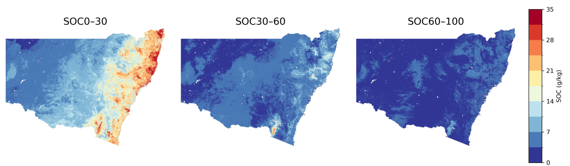
The digital soil mapping project of key soil properties over NSW combines high-resolution digital soil maps with climate projections to assess how future climatic conditions may influence soil properties across NSW.
Using a 100-m resolution baseline, we model key soil attributes – such as soil organic carbon (SOC) (e.g. Figure 1), cation exchange capacity, bulk density, texture fractions (sand, silt, clay), pH, phosphorus, moisture, nitrogen, and macro-nutrient content – across three depth intervals (0–30 cm, 30–60 cm, and 60–100 cm). These projections are informed by 10 future ensembles derived from the NSW and Australian Regional Climate Modelling (NARCliM2.0), which includes 5 global climate models and 2 regional downscaling models under a low, medium and high-emission scenarios (e.g. Figure 2 and 3).
Key findings
Climate change will significantly affect soil properties across NSW, with greater impacts expected by 2080–2100, especially under a high-emission scenario (SSP3-7.0).
The research shows state and localised trends (from the projected climate change impacts):
- Projected changes in soil organic carbon (SOC) show a consistent decline across most of NSW under all future climate scenarios.
- The strongest decreases appear in the western and northwestern regions, while parts of eastern NSW show smaller reductions or slight increases in some scenarios.
- Overall, SOC is projected to decline statewide, with the scale varying by scenario and time periods.
- Other properties – such as pH, cation exchange capacity, bulk density, pH, and nutrient levels – also vary across climate change scenarios. For example, reduced moisture in central NSW may limit microbial activity and nutrient cycling, while pH shifts could influence crop suitability.

These findings highlight the need for proactive strategies to maintain soil health and support climate-resilient land use across NSW.
Applications of the data
The development of high-resolution maps helps identify vulnerable zones, such as areas with declining carbon or increasing salinity, which can support and enable targeted soil management and restoration efforts.
Adaptation strategies
To build climate-resilient soils, land management should focus on increasing soil carbon1 through conservation land use, cover crops and organic amendments. These practices help maintain fertility, improve water retention and support long-term productivity.
Using high-resolution soil maps and climate projections enables targeted interventions. Regions facing moisture loss or nutrient decline can benefit from tailored strategies like mulching, reduced tillage or crop rotation.
Digital soil mapping outputs should be integrated into regional planning to guide sustainable agriculture and land use. This supports informed decision-making and prioritizes areas needing restoration or protection.
Long-term monitoring is essential to track soil changes. Consistent data collection and remote sensing can help detect trends and refine future models.
Collaboration among researchers, land managers, and policymakers is key to developing practical, scalable solutions. Shared data and coordinated planning will enhance resilience across NSW landscapes.
References
- NSW Department of Primary Industries and Regional Development, Soil carbon sequestration. Accessed 27/11/25
Further reading
Ma, Y., Minasny, B., Malone, B.P. and Mcbratney, A.B. Pedology and digital soil mapping (DSM). European Journal of Soil Science, 2019; 70: 216-235. https://doi.org/10.1111/ejss.12790
Ma, Y.; Minasny, B.; Viaud, V.; Walter, C.; Malone, B.; McBratney, A. Modelling the Whole Profile Soil Organic Carbon Dynamics Considering Soil Redistribution under Future Climate Change and Landscape Projections over the Lower Hunter Valley, Australia. Land 2023, 12, 255. doi:https://doi.org/10.3390/land12010255
Ma, Y.; Minasny, B,; McBratney, A.; Poggio, L.; Fajardo, M.; Predicting soil properties in 3D: Should depth be a covariate?, Geoderma, 2021, Volume 383, doi: https://doi.org/10.1016/j.geoderma.2020.114794.
Zhang, M; Shi W, Ren Y; Wang Z; Ge Y; Guo Y; Mao D; Ma Y; Proportional allocation with soil depth improved mapping soil organic carbon stocks, Soil and Tillage Research, 2022, Volume 224, doi: https://doi.org/10.1016/j.still.2022.105519.
Ma Y; Minasny B; Dimuth W D; Welivitiya P; Malone B P; Willgoose G R; McBratney A B; The feasibility of predicting the spatial pattern of soil particle-size distribution using a pedogenesis model, Geoderma, 2019, Volume 341, Pages 195-205, doi: https://doi.org/10.1016/j.geoderma.2019.01.049.
eSPADE: Soil and landscape spatial viewer
NSW Department of Climate Change, Energy, the Environment and Water, Land and soil information | Land and Soil | Environment and Heritage Accessed 19/11/2025
Gray JM (2023) Digital soil mapping key soil properties over NSW, version 2.0, Technical Report, NSW Department of Climate Change, Energy, the Environment and Water.
NSW Department of Primary Industries and Regional Development. Soil management guides. NSW Government website. Accessed 19/11/2025
Linked Datasets
Digital soil maps (DSMs) are prepared through quantitative modelling techniques that are based on re...
- GEOTIFF