Mapping species distribution under climate change
Key messages
- Climate change is affecting the amount and distributions of habitats for native animals, generally leading to increased extinction risk for threatened species.
- Mapping landscape capacity identifies the capability of a population to respond to changes to their habitat – either from human-influence or changes in climate.
- Climate-informed data and analysis can assist in reducing climate risk to biodiversity and supporting adaptation and conservation measures.
- The Persistence in Landscapes Project identifies important areas for conservation and restoration for 75 landscape-managed fauna species to inform improved conservation decisions and reduced extinction risk for species.
Context
Persistence in Landscapes Project
The Persistence in Landscapes Project (PLP) was undertaken by the NSW Government, funded by the Saving Our Species program and the Science and Insights division in DCCEEW in collaboration with Macquarie University and University of New England.
It aimed to:
- assess the risk to landscape-dependent threatened species
- identify and help prioritise places where suitable habitat is likely to exist for each species, now and under projected climate change, assuming the extent of native vegetation is kept constant
- consider where populations of each species can potentially continue, with sufficient resources at the home range scale (the spatial scale at which a species moves daily), and sufficiently connected habitat at the dispersal scale (the spatial scale at which a species disperses to colonise new ranges)
- help identify actions to minimise extinction risk through climate change – brought about primarily through shifting and reduced habitats
- identify key areas for conservation action across NSW.
A changing landscape
As our climate changes so too does species distribution. Through identification of climate refugia areas and assessing where species may be able to shift to in response to changing climate zones and impacts, this project’s data and mapping provide sustainable, and suitable, conservation options into the future.
The Persistence in Landscapes Project brings together conservation adaptation actions, climate science and species data and modelling to provide tools to guide practical action.
Outputs for the 75 landscape-managed fauna species analysed as part of the project include sets of maps or grids predicting landscape capacity for each species over the next 50 years, as well as individual species forecasts.
These maps and forecasts identified where species populations can persist through expected geographic shifts to their climatic envelopes due to projected climate change.
Key findings
Total landscape capacity changes
‘Landscape capacity’ is the amount of useable habitat for the species population. High landscape capacity means a location is of suitable type and condition and has sufficient connectivity to neighbouring habitat to support a viable population. Low means it does not.
The datasets and species forecasts maps help to identify species that do not have the ability, or opportunity, to move and adapt to future conditions.
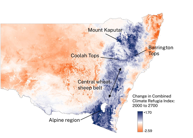
Example locations with relatively high increases are indicated
Species with smaller habitat range, or whom have already been significantly impacted by human and climate-induced impacts, such as the giant burrowing frog, face significant reductions in the projections.
Using the years 1750, 2000 and climate projections to 2070 (NSW and Australia Regional Climate Modelling (NARCliM1.0) project), the PLP species forecasts identified that of the 75 species mapped
- 53% of species future projected landscape capacity was identified as ‘Poor’ (> 30% lost between 2000 and 2070 or < 5% of 1750 remaining by 2070)
- 32% species future projected landscape capacity was identified as ‘Moderate’ (> 10% lost between 2000 and 2070 or < 10% of 1750 remaining by 2070)
- 15% species future projected landscape capacity was identified as ‘Good’ (< 10% lost between 2000 and 2070 and > 10% of 1750 remaining by 2070).
The forecasts highlight the importance in identifying locations of refugia, or important areas that currently support occupancy and are expected to continue supporting relatively high densities of species into the future.
Forecasts suggest areas where some species may have the potential to adapt to climate change by occupying new areas, if they can be supported through targeted, on-ground management such as translocation or creation of habitat linkages.
The data and maps show areas where multiple species could persist and how the ‘summed landscape capacity’ across all species included in the project is expected to change over time.
Application of the data
Threatened fauna species with widespread distributions and large home ranges cannot be contained within well-defined sites, presenting challenges for conservation.
The Persistence in Landscapes Project approach reduces that uncertainty around the impacts of climate change. By modelling ‘landscape capacity’ into the future, the project can be used to guide on-ground conservation management actions for landscape-managed species.
By identifying where and how species are distributed, conservation actions can be guided by where it will have the most impact across multiple species, from a climate-adaptation perspective.
The PLP dataset helps users identify priority areas now and under future climate scenarios to support landscape-managed threatened fauna species.
Credits
The Persistence in Landscapes Project has been a collaboration involving the NSW Department of Climate Change, Energy, the Environment and Water, the University of New England and Macquarie University. An extensive process of expert elicitation and review at various stages of the modelling project has drawn on ecologists from the department, other agencies, universities and private individuals.
Modelling
The modelling for each species was undertaken using environmental niche modelling (ENM) to predict the distribution of suitable habitat across New South Wales in the years 1750, 2000, and projected to 2030 and 2070 using climate projections from the NSW and Australia Regional Climate Modelling (NARCliM1.0) project. It considered the type and condition of habitat, its extent and distribution, and the amount of connected habitat available for populations through time and across various climate scenarios.
The Persistence in the Landscape Project technical report, NSW DCCEEW.
Persistence in Landscapes - modelling future-ready conservation options for landscape managed threatened fauna. Department of Climate Change, Energy, the Environment and Water (2025).
Individual species forecasts for 75 species:
https://datasets.seed.nsw.gov.au/dataset/climate-informed-plp-modelling/resource/27c36e75-690e-4fcd-88b4-b89bbdfafeba
Linked Datasets
Modelling of landscape capacity for 75 landscape-managed NSW threatened species. Landscape capac...
- GEOTIFF